Reviews and reports
Mineral Resources and Reserves
| Manganese ore mines | MEASURED AND INDICATED | PROVED AND PROBABLE | ||||
| Mineral Resources | Mineral Reserves | |||||
| Mt | Mn % | Fe % | Mt | Mn % | Fe % | |
| NCHWANING | ||||||
| No 1 Seam | 126,69 | 44,9 | 8,6 | 106,28 | 44,9 | 8,6 |
| No 2 Seam | 180,80 | 42,4 | 15,5 | – | – | – |
| GLORIA | ||||||
| No 1 Seam | 92,23 | 37,8 | 4,9 | 68,25 | 37,8 | 4,9 |
| No 2 Seam | 29,40 | 29,9 | 10,1 | – | – | – |
| BLACK ROCK | ||||||
| No 1 Seam | 43,60 | 40,6 | 18,1 | – | – | – |
| No 2 Seam | 26,81 | 38,6 | 19,8 | – | – | – |
| Chromite mine | MEASURED AND INDICATED | PROVED AND PROBABLE | ||
| Mineral Resources | Mineral Reserves | |||
| Mt | Cr2O3% | Mt | Cr2O3% | |
| DWARSRIVIER | 48,77 | 39,05 | 33,44 | 35,69 |
Subsidiary companies
| Mineral Resources | Mineral Reserves | ||||||
| Measured | Indicated | Inferred | Total | Proved | Probable | Total | |
| Mt | Mt | Mt | Resource | Mt | Mt | Reserve | |
| Chromite mines | |||||||
| Rustenburg Minerals | 3,4 | 2,2 | 7,7 | 13,3 | 2,7 | 1,8 | 4,5 |
| Zeerust Chrome | 1,9 | 1,5 | 8,4 | 11,8 | 2,4 | 5,2 | 7,6 |
| Pyrophyllite mine | |||||||
| Wonderstone | 3,5 | 0,0 | 104,8 | 108,3 | 3,3 | 3,3 | |
Salient features for the year ended 30 June 2011
| Khumani | Waste stripping at King progressed in preparation for production. |
| Beeshoek | Production mainly for the domestic market came from offgrade stockpiles processed through the jig plant. |
| Nchwaning | Investigations initiated to model the full package of the manganese seams in 0,5 m layers. |
| Gloria | Measured and Indicated Mineral Resources increased by 79% to 92,23 million tons at 37,8% Mn as a result of remodelling which incorporated 42 new additional surface boreholes. The Inferred Resource decreased to 84 million tons. |
| Dwarsrivier | Surface drilling of 52 boreholes to upgrade the Mineral Resource confidence in the southern portion of the mine completed. Remodelling to commence when all assay results are received. |
Competent person's report on Mineral Resources and Mineral Reserves 2011
This report is issued as the annual update of Mineral Resources and Reserves to inform shareholders and potential investors of the mineral assets held by Assmang Limited.
General statement
Assmang's method of reporting Mineral Resources and Mineral Reserves conforms to the South African Code for Reporting Mineral Resources and Mineral Reserves (SAMREC Code) and the Australian Institute of Mining and Metallurgy Joint Ore Reserves Committee Code (JORC Code).
The convention adopted in this report is that Mineral Resources are reported inclusive of that portion of the total Mineral Resource converted to a Mineral Reserve. Resources and reserves are quoted as at 30 June 2011. External consulting firms audit the resources and reserves of the Assmang operations on a three to four-year cycle basis.
Underground resources are in situ tonnages at the postulated mining width, after deductions for geological losses.
Underground Mineral Reserves reflect milled tonnages while surface Mineral Reserves (dumps) are in situ tonnages without dilution. Both are quoted at the grade fed to the plant. Open-pit Mineral Resources are quoted as in situ tonnages and Mineral Reserves are tonnages falling within an economic pit-shell.
The evaluation method is generally Ordinary Kriging with mining block sizes ranging from 10 x 10 metres to 100 x 100 metres to 250 x 250 metres in the plan view. The blocks vary in thickness from 2,5 to 10 metres. The evaluation process is fully computerised, generally utilising the Datamine software package.
The Mineral Resources and Mineral Reserves are reported on a total basis regardless of the attributable beneficial interest that Assmang has on the individual projects or mines. When the attributable beneficial interests on a mine or project is less than 100%, the actual percentage of the attributable interest is specified.
Maps, plans and reports supporting resources and reserves are available for inspection at Assmang's registered office and at the relevant mines.
In order to satisfy the requirements of the Minerals and Petroleum Resources Development Act, Assmang's operations will have to obtain new mining rights for all properties required to support the planned operations over the next 30 years. The act was effective from 1 May 2004 and the new rights must be obtained within five years from then. The operations are at various stages of application.
Rounding of figures may result in computational discrepancies on the Mineral Resource and Reserve tabulations.
Definitions
The definitions of Mineral Resources and Reserves, quoted from the SAMREC Code, are as follows:
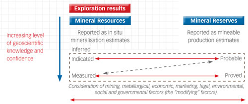
A "Mineral Resource" is a concentration or occurrence of material of economic interest in or on the earth's crust in such form, quality and quantity that there are reasonable and realistic prospects for eventual economic extraction. The location, quantity, grade, continuity and other geological characteristics of a Mineral Resource are known, or estimated from specific geological evidence, sampling and knowledge interpreted from an appropriately constrained and portrayed geological model. Mineral Resources are sub-divided, and must be so reported, in order of increasing confidence in respect of geoscientific evidence, into Inferred, Indicated or Measured categories.
An "Inferred Mineral Resource" is that part of a Mineral Resource for which volume or tonnage, grade and mineral content can be estimated with only a low level of confidence. It is inferred from geological evidence and sampling and assumed but not verified geologically or through analysis of grade continuity. It is based on information gathered through appropriate techniques from locations such as outcrops, trenches, pits, workings and drill holes that may be limited in scope or of uncertain quality and reliability.
An "Indicated Minera" Resource" is that part of a Mineral Resource for which tonnage, densities, shape, physical characteristics, grade and mineral content can be estimated with a reasonable level of confidence. It is based on information from exploration, sampling and testing of material gathered from locations such as outcrops, trenches, pits, workings and drill holes. The locations are too widely or inappropriately spaced to confirm geological or grade continuity but are spaced closely enough for continuity to be assumed.
A "Measured Mineral Resource" is that part of a Mineral Resource for which tonnage, densities, shape, physical characteristics, grade and mineral content can be estimated with a high level of confidence. It is based on detailed and reliable information from exploration, sampling and testing of material from locations such as outcrops, trenches, pits, workings and drill holes. The locations are spaced closely enough to confirm geological and grade continuity.
A "Mineral Reserve" is the economically mineable material derived from a Measured or Indicated Mineral Resource or both. It includes diluting and contaminating materials and allows for losses that are expected to occur when the material is mined. Appropriate assessments to a minimum of a pre-feasibility study for a project and a life-of-mine plan for an operation must have been completed, including consideration of, and modification by, realistically assumed mining, metallurgical, economic, marketing, legal, environmental, social and governmental factors (the modifying factors). Such modifying factors must be disclosed.
A "Probable Mineral Reserve" is the economically mineable material derived from a Measured or Indicated Mineral Resource or both. It is estimated with a lower level of confidence than a Proved Mineral Reserve. It includes diluting and contaminating materials and allows for losses that are expected to occur when the material is mined. Appropriate assessments to a minimum of a pre-feasibility study for a project or a life-of-mine plan for an operation must have been carried out, including consideration of, and modification by, realistically assumed mining, metallurgical, economic, marketing, legal, environmental, social and governmental factors. Such modifying factors must be disclosed.
A "Proved Mineral Reserve" is the economically mineable material derived from a Measured Mineral Resource. It is estimated with a high level of confidence. It includes diluting and contaminating materials and allows for losses that are expected to occur when the material is mined. Appropriate assessments to a minimum of a pre-feasibility study for a project or a life-of-mine plan for an operation must have been carried out, including consideration of, and modification by, realistically assumed mining, metallurgical, economic, marketing, legal, environmental, social and governmental factors. Such modifying factors must be disclosed.
Iron ore mines
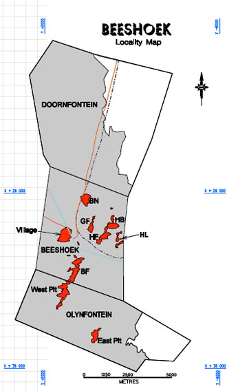
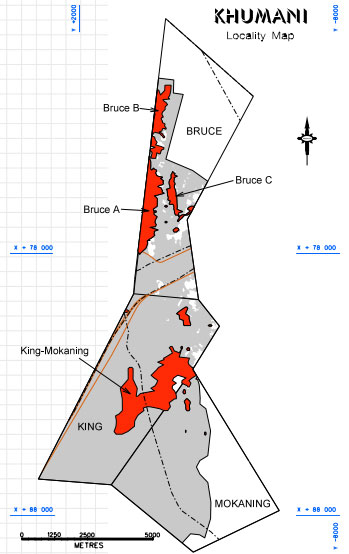
Locality – The iron ore division is made up of the Beeshoek Mine located on the farms Beeshoek (448) and Olynfontein (475), and the Khumani Mine situated on the farms Bruce (544), King (561) and Mokaning (560). All properties are in the Northern Cape approximately 200 kilometres west of Kimberley. The Beeshoek open-pit operations are situated 7 kilometres west of Postmasburg and the new Khumani open pits are adjacent to, and south-east of, the Sishen mine, which is operated by Kumba Resources. Located at latitude 28°30'00"S/longitude 23°01'00"E, and latitude 27°45'00"S/longitude 23°00'00"E respectively. Khumani Mine supplies iron ore to the export markets. Exports are railed to the iron ore terminal at Saldanha Bay. Beeshoek ore is supplied to local customers.
History – Mining of iron ore (mainly specularite) was undertaken as early as 40 000 BC on the farm Doornfontein which is due north of Beeshoek. The potential of iron ore in this region was discovered in 1909, but due to the lack of demand and limited infrastructure, this commodity was given little attention. In 1929 the railway line was extended from Koopmansfontein (near Kimberley) to service a manganese mine at Beeshoek. In 1935 the Associated Manganese Mines of South Africa Limited (Assmang) was formed, and in 1964 the Beeshoek iron ore mine was established, with a basic hand sorting operation. In 1975 a full washing and screening plant was installed and production increased to seven million tons over the years. The Khumani Iron Ore Mine was commissioned in 2007 and is ramping up to approximately 10 million tons per annum w
Mining authorisation – The Beeshoek mining lease (ML3/93) comprises an area of 5 686 hectares and is located on the farms Beeshoek (448) and Olynfontein (475). The application for the conversion to a new mining order right submitted during the 2009 financial year is still pending. The application has been forwarded to Pretoria from the Kimberly regional office recommending its approval.
The Khumani mining right comprises an area of 7 388 hectares and is located on the farms Bruce (544), King (561) and Mokaning (560). The mining right was granted during the 2007 financial year.
Geology – The iron ore deposits are contained within a sequence of early Proterozoic sediments of the Transvaal Supergroup deposited between 2 500 and 2 200 million years ago. In general two ore types are present, namely laminated hematite ore forming part of the Manganore Iron Formation and conglomerate ore belonging to the Doornfontein Conglomerate Member at the base of the Gamagara Formation.
The older laminated ore types occur in the upper portion of the Manganore Iron Formation as enriched high-grade hematite bodies. The boundaries of high-grade hematite orebodies crosscut primary sedimentary bedding, indicating that secondary hematitisation of the iron formation took place. In all of these, some of the stratigraphic and sedimentological features of the original iron formation are preserved.
The conglomeratic ore is found in the Doornfontein Conglomerate Member of the Gamagara Formation and is lenticular and not persistently developed along strike. It consists of stacked, upward fining conglomerate-gritstone-shale sedimentary cycles. The lowest conglomerates and gritstones tend to be rich in sub-rounded to rounded hematite ore pebbles and granules and form the main orebodies. The amount of iron ore pebbles decreases upwards in the sequence so that upper conglomerates normally consist of poorly sorted, angular to rounded chert and banded iron formation pebbles.
The erosion of the northern Khumani deposit is less than that in the southern Beeshoek area. The result is that Khumani is characterised by larger stratiform bodies and prominent hangingwall outcrops. The down-dip portions are well preserved and developed, but in outcrop the deposits are thin and isolated. Numerous deeper extensions occur into the basins due to karst development. A prominent north-south strike of the ore is visible. The southern Beeshoek orebodies were exposed to more erosion and are more localised and smaller. Outcrops are limited to the higher topography on the eastern side of the properties. Down dip to the west, the ore is thin and deep. The strike of the orebodies is also in a north-south direction, but less continuous.
Hematite is the predominant ore mineral, but limonite and specularite also occur. Mining operations are all open pit, based on the conventional drill-and-blast, truck-and-shovel operations. Run-of-mine ore is crushed and stored as on or off-grade on blending stockpiles. Ore from the stockpiles is either sent to the wash-and-screen plants or, if off-grade, to the beneficiation plants. The washing and screening plants consist primarily of tertiary crushing, washing, screening, conveying and stacking equipment. The beneficiation plants consist of tertiary crushers; scrubbers; coarse and fine jigs; lumpy, fines and scaw product stockpiles; and a rapid load-out facility. No chemical is being used in any of the treatment plants.
Mineral Resources and Reserves – In the iron ore operations, the following table shows how the search ellipse (ie the ellipsoid used by the Kriging process to determine if a sample is used in the estimation of a block) is used to classify the Mineral Resources:
| Search | |||
| Minimum | Maximum | ellipse | |
| number | number | settings | |
| of samples | of samples | XYZ (m) | |
| Measured | 6 | 30 | 100 x 100 x 10 |
| Indicated | 5 | 30 | 200 x 200 x 20 |
| Inferred | 4 | 30 | 400 |
Only Measured and Indicated Resources are converted to Proved and Probable Reserves respectively. Modifying factors were applied to these resources and financially optimised. The financial outline is used to define the optimal pit by means of the Lersch-Grossman algorithm. The resources within this mining constraint are defined as reserves. These are categorised into different product types, destined for the different plant processes and scheduled for planning
The methodology followed to identify targets is initiated with geological mapping, followed by geophysics (ground magnetics and gravity). Percussion drilling is used to pilot holes through overlying waste rock down to the iron orebodies. Diamond drilling is the next phase, which is usually on a 200 x 200 metre grid. Further infill drilling is carried out at spacing ranging from 100 x 100 metres to 25 x 25 metres, depending on the complexity of the geological structures. Numerous exploration programmes have been completed in the last 40 years. A total of 2 832 holes (1 315 holes on Khumani and 1 517 holes on Beeshoek) have been drilled. Core samples are logged and split by means of a diamond saw and the half-core is sampled every 0,5 metres. Before submission for assaying, the half-cores are crushed, split and pulverised. Samples with values larger than 60% are included in the definition of the orebodies. Any lower-grade samples inside the orebody are defined as internal waste and modelled separately. Each zone is modelled per section, and then wireframed to get a three-dimensional (3D) model.
Ordinary Kriging interpolation within CAE Datamine is used to estimate the grade of each 10 x 10 x 10 metre block generated within the geological model. Density in the resource model is calculated using a fourth degree polynomial fit applied to the estimated Fe grade. Densities range from 4,38 t/m3 (60% Fe) to 5,01 t/m3 (68% Fe). A default density of 3,2 t/m3 is used for waste.
At the Iron Ore Mines all blast holes are sampled per metre, but composited per hole. All holes are analysed for density and blast holes in ore are sampled and analysed for Fe, potassium oxide (K2O), sodium oxide (Na2O), silica (SiO2), aluminium oxide (Al2O3), phosphorus (P), sulphur (S), CaO, MgO, Mn and barium oxide (BaO). Every fifth blast hole is geologically logged per metre, which is used to update the geological model. The chemical results of these holes are used to update the ore block model. The major analytical technique for elemental analyses is XRF spectroscopy. Volumetric titration is used as verification method for the determination of total iron in the ore. International standards (eg SARM11) and in-house iron standards are used for calibration of the XRF spectrometer. The Khumani laboratory participates in a round robin group that includes 11 laboratories for verification of assay results.
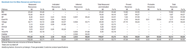
Beeshoek year-on-year change – Measured and Indicated Resources for the Beeshoek Mine increased to 118,97 million tonnes from 113,35 million tons, mainly due to the increase in the resources for Village pit where remodelling of the orebody was undertaken. The 2011 Mineral Reserves increased by 16% to 55,13 million tons due to increase in Village and East Pit reserves. A feasibility study for Village pit is still in progress.
Click the image to view an enlarged version
| Beeshoek Iron Ore Mine: Resources and Reserves |
 Click the image to view an enlarged version |
Click the image to view an enlarged version
Khumani year-on-year change – At the Khumani Mine Measured and Indicated Resources decreased from 613,73 million tons to 603,43 million tons mainly due to Bruce B and C pits where reduced tonnage is attributable to mining depletion and remodelling of Bruce C. Total reserves increased marginally to 545,36 from 543,63 million tons in 2010.
| Historical production at the Beeshoek and Khumani Mines (saleable product) | ||
| Beeshoek | Khumani | |
| Financial year | Mt | Mt |
| 2006/2007 | 6,70 | – |
| 2007/2008 | 5,30 | 2,00 |
| 2008/2009 | 2,66 | 6,65 |
| 2009/2010 | 0,52 | 8,77 |
| 2010/2011 | 0,96 | 8,73 |
| Khumani Iron Ore Mine: Resources and Reserves |
 Click the image to view an enlarged version |
Manganese mines
Locality – The manganese mines are situated in the Northern Cape province in South Africa, approximately 80 kilometres north-west of the town of Kuruman. Located at latitude 27°07'50"S and longitude 22°50'50"E, the site is accessed via the national N14 route between Johannesburg and Kuruman, and the provincial R31 road.
History – In 1940, Assmang acquired a manganese ore outcrop on a small hillock known as Black Rock. Several large properties underlain by ore were subsequently found and acquired. Today the Black Rock area is considered to be the largest and richest manganese deposit in the world. Manganese ore operations were extended and today include the Gloria and Nchwaning underground mines. Manganese ore is supplied locally to Assmang-owned smelters, but is mainly exported through Port Elizabeth to Japanese and German customers.
Mining authorisation – The Nchwaning mining lease (ML10/76) comprises an area of 1 986 hectares and is located on the farms Nchwaning (267), Santoy (230) and Belgravia (264). The Gloria mining lease (ML11/83) comprises an area of 1 713 hectares and is located on portion 1 of the farm Gloria (266). The new mining right was executed on 13 July 2011. Registration of the right is in process.
Geology – The manganese ores of the Kalahari Manganese field are contained within sediments of the Hotazel Formation of the Griqualand West Sequence, a subdivision of the Proterozoic Transvaal Supergroup. At Black Rock, Belgravia and Nchwaning, the Hotazel, Mapedi and Lucknow Formations have been duplicated by thrusting. The thrusted orebodies comprising Black Rock (Koppie), Belgravia 1 and Belgravia 2 are collectively known as Black Rock orebodies. The average thickness of the Hotazel Formation is approximately 40 metres.
The manganese orebodies exhibit a complex mineralogy and more than 200 mineral species have been identified to date. The hydrothermal upgrading has resulted in a zoning of the orebody with regard to fault positions. Distal areas exhibit more original and low-grade kutnohorite and braunite assemblages, while areas immediately adjacent to faults exhibit a very high-grade hausmannite ore. The intermediate areas exhibit a very complex mineralogy, which includes bixbyite, braunite and jacobsite amongst a host of other manganese-bearing minerals. A similar type of zoning also exists in the vertical sense. At the top and bottom contacts it is common to have high iron (Fe) and low manganese (Mn) contents while the reverse is true towards the centre of the seam. This vertical zoning has given rise to a mining practice where only the centre 3,5-metre high portion of the seam is being mined. At the Gloria Mine the intensity of faulting is much less, which also explains the lower grade.
Two manganese seams are present. The No 1 seam is up to 6 metres in thickness, of which 3,5 metres are mined, using a manganese marker zone for control. There is, therefore, minimum dilution. No mining is presently undertaken on No 2 seam at Nchwaning or Gloria.
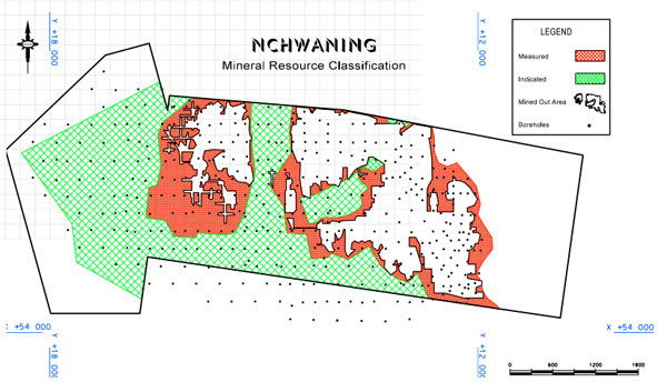
Nchwaning Mineral Resources and Reserves Mineral Resource classification at the Nchwaning Mine is based on consideration of a number of parameters: kriging variance, kriging efficiency, regression slope, geological structures and quality of assay data. Each of these parameters contributes to the overall classification depending on weighting assigned to each of the parameters. Measured and Indicated Resources have been defined for Nchwaning. Geological losses are built into the grade models.
The Nchwaning Mine was diamond drilled from surface at 330 metre centres and the data is now captured in a Geological Database Management System (GDMS) developed by CAE Datamine SA. The core was logged and 0,5-metre long, halfcore, diamond-saw cut samples were submitted to Assmang's laboratory at Black Rock for X-ray fluorescence (XRF) analyses. Mn and Fe values were checked by Wet Chemical analyses. Several standards were used to calibrate XRF equipment, and results are compared with other laboratories on a regular basis.
At Nchwaning a total of 316 boreholes as well as a total of 30 587 face samples were considered in the grade estimation for the Nchwaning 1 orebody. The available data for an area was optimised over a thickness of 3,5 metres and exported into data files for computerised statistical and geostatistical manipulation to determine the average grades of Mn, Fe, silica (SiO2), calcium (CaO) and magnesium (MgO).
Ordinary Kriging interpolation within Datamine was used to estimate the grade of each 50 x 50 x 3,5 metre block generated within the geological model.
Sub-cell splitting of the 50 x 50 metre blocks was allowed to follow the geological boundaries accurately. The relative density of Nchwaning manganese ore was taken as 4,3 t/m3.
Trackless mechanised equipment is used in the board and pillar mining method. Mining in the eastern extremity of Nchwaning occurs at a depth of 200 metres while the deepest (current) excavations can be found at a depth of 519 metres below surface.
Ore from the Nchwaning No 2 Mine is crushed underground before being hoisted to a surface stockpile via a vertical shaft. Similarly, ore from the Nchwaning No 3 Mine is crushed underground before being conveyed to a surface stockpile via a declined conveyor system. Ore is withdrawn from the surface stockpile and forwarded to two stages of crushing, dry screening and wet screening to yield lumpy and fine products.
Nchwaning year-on-year change – Mineral Reserves for Nchwaning lower seam (1 body) decreased to 106,28 million tons from 107,96 million tons mainly due to depletion by production. The Mineral Resources for 1 body changed from 128,63 million tons to 126,69 million tons. Nchwaning 2 body Mineral Resources remained at 180,8 million tons.
At the plant the finer fractions are stockpiled while the coarser fractions are extracted from the respective product boxes into road haulers, sampled, weighed and stored on stacks ahead of despatch. Samples from each stack are analysed for chemical content and size distribution. This ensures good quality control and enables the ore control department to blend various stacks according to customer demand.
Nchwaning year-on-year change – Mineral Reserves for Nchwaning lower seam (1 body) decreased to 106,28 million tons from 107,96 million tons mainly due to depletion by production. The Mineral Resources for 1 body changed from 128,63 million tons to 126,69 million tons. Nchwaning 2 body Mineral Resources remained at 180,8 million tons.
| Nchwaning Mine: Lower Seam (1 Body) Manganese Resources and Reserves | |||||||
| Mineral Resources | Mt | Mn % | Fe % | Mineral Reserves | Mt | Mn % | Fe % |
| Measured | 37,61 | 46,3 | 9,0 | Proved | 32,34 | 46,3 | 9,0 |
| Indicated | 89,08 | 44,3 | 8,4 | Probable | 73,94 | 44,3 | 8,4 |
| Total Resources 1 body 2011 | 126,69 | 44,9 | 8,6 | Total Reserves 1 body 2011 | 106,28 | 44,9 | 8,6 |
| Total Resources 1 body 2010 | 128,63 | 45,3 | 8,7 | Total Reserves 1 body 2010 | 107,96 | 45,3 | 8,7 |
| Mineral Resources are inclusive of Mineral Reserves. | |||||||
| Totals are rounded off. | |||||||
| Modifying factors: pillar losses, mining losses. | |||||||
| Nchwaning Mine: Upper Seam (2 body) Manganese Resources | |||
| Mineral Resources | Mt | Mn % | Fe % |
| Measured | 53,37 | 42,0 | 16,3 |
| Indicated | 27,43 | 42,6 | 15,2 |
| Total Resources 2 body 2011 | 180,80 | 42,4 | 15,5 |
| Total Resources2 body 2010 | 180,80 | 42,4 | 15,5 |
Black Rock Mineral Resources
The Black Rock orebodies occur in the Black Rock (Koppie),
Belgravia 1 and Belgravia 2 areas. They are all part of a large
thrust complex. Modelling of these orebodies was undertaken
using 151 Nchwaning boreholes that intersected the thrust
complex and 174 Black Rock infill boreholes. A cut-off of 38%
manganese was used in the modelling. 1 and 2 body seams were
modelled at different thicknesses.
| Black Rock: Lower Seam (1 body) Manganese Resources | |||
| Mineral Resources | Mt | Mn % | Fe % |
| Measured | 9,03 | 40,3 | 18,1 |
| Indicated | 34,57 | 40,7 | 18,1 |
| Total Resources 1 body 2011 | 43,60 | 40,6 | 18,1 |
| Total Resources 1 body 2010 | – | – | – |
| Totals are rounded off. | |||
| Black Rock: Lower Seam (2 body) Manganese Resources | |||
| Mineral Resources | Mt | Mn % | Fe % |
| Measured | 8,23 | 37,4 | 19,8 |
| Indicated | 18,58 | 39,2 | 19,8 |
| Total Resources 2 body 2011 | 26,81 | 38,6 | 19,8 |
| Total Resources 2 body 2010 | – | – | – |
Click the image to view an enlarged version
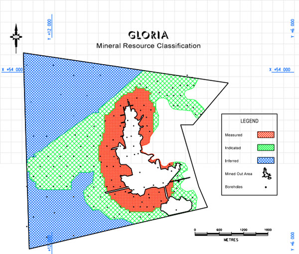
Gloria Mineral Resources and Reserves
Procedures for drilling and assaying at the Gloria Mine are
the same as at Nchwaning. A total of 109 boreholes and
6 480 face samples were considered in the evaluation of the
Gloria 1 Body Mine. The underground sampling values were used
in evaluating areas close to current mining. The boreholes were
optimised over a stoping width of 3,5 metres and the relative
density was taken as 3,8 t/m3. The seams were evaluated by
means of statistical and geostatistical methods to determine the
average grades of Mn, Fe, SiO2, CaO and MgO. Ordinary Kriging
interpolation within Datamine was used to estimate the grade of
each 50 x 50 x 3,5 metre block generated within the geological
model. Sub-cell splitting of the 50 x 50 metre blocks was allowed
to follow the geological boundaries.
The Gloria Mine is extracting manganese at depths that vary between 180 to 250 metres. Ore is crushed underground before being conveyed to surface stockpile via a decline shaft.
Gloria year-on-year change – Remodelling of the Gloria orebody after drilling of 42 new boreholes resulted in significant 79% increase in Measured and Indicated Mineral Resources to 92,23 million tons as the Inferred Resources were upgraded to higher category resources. Mineral Reserves also increased from 39,71 million tons to 68,25 million tons. The Mineral Resources for Gloria 2 body remained the same. No South African markets exist for Gloria 2 body ore at this time.
| Gloria Mine: Lower Seam (1 body) Manganese Resources and Reserves | |||||||
| Mineral Resources | Mt % | Mn % | Fe % | Mineral Reserves | Mt % | Mn % | Fe % |
| Measured | 31,46 | 37,7 | 4,8 | Proved | 23,28 | 37,7 | 4,8 |
| Indicated | 60,77 | 37,8 | 4,9 | Probable | 44,97 | 37,8 | 4,9 |
| Total Resources 1 body 2011 | 92,23 | 37,8 | 4,9 | Total Reserves 1 body 2010 | 68,25 | 37,8 | 4,9 |
| Total Resources 1 body 2010 | 51,57 | 38,3 | 5,5 | Total Reserves 1 body 2009 | 39,71 | 38,3 | 5,5 |
| Inferred 2011 | 84,00 | 36,8 | 4,8 | ||||
| Inferred 2010 | 128,24 | – | – | ||||
| Mineral Resources are inclusive of Mineral Reserves. | |||||||
| Totals are rounded off. | |||||||
| Modifying factors: pillar losses, mining losses. | |||||||
| Gloria Mine: Upper Seam (2 body) Manganese Resources | |||
| Mineral Resources | Mt | Mn % | Fe % |
| Measured | – | – | – |
| Indicated | 29,40 | 29,9 | 10,1 |
| Total Resources2 body 2011 | 29,40 | 29,9 | 10,1 |
| Total Resources2 body 2010 | 29,40 | 29,9 | 10,1 |
| Inferred 2011 | 128,24 | – | – |
| Inferred 2010 | 128,24 | – | – |
| Totals are rounded off. | |||
| Historical manganese production at the Nchwaning and Gloria Mines (Saleable product) | ||
| Nchwaning | Gloria | |
| Year | Mt | Mt |
| 2006/2007 | 2,49 | 0,43 |
| 2007/2008 | 2,71 | 0,41 |
| 2008/2009 | 2,63 | 0,51 |
| 2009/2010 | 1,30 | 0,67 |
| 2010/2011 | 2,35 | 0,70 |
Click the image to view an enlarged version
Chromite mine
Locality – Chromite operations at the Dwarsrivier Mine form part of the chrome division of Assmang Limited. The mine is situated on the farm Dwarsrivier (372KT), approximately 30 kilometres from Steelpoort and 60 kilometres from Lydenburg, in the Mpumalanga province in South Africa. Located at longitude 30°05'00"E/latitude 24°59'00"S, Assmang purchased the farm from Gold Fields Limited, together with all surface and mineral rights in October 1998.
History – Neighbouring properties to the north and south of Dwarsrivier had existing chrome mining operations at the time of purchase. The feasibility study of the plant, tailings dam and designs for the open-cast and underground mines then commenced. After the completion of the feasibility study, approval to proceed with the final design and construction work was given in July 1999.
Chromite was obtained from the open-cast mining areas at a rate of approximately 0,9 million tons a year and these areas were mined out within five years. Underground mining commenced in 2005 at a rate of 1,2 million tons ROM a year. The Dwarsrivier Mine is specifically geared to deliver high-quality metallurgical grade chromite to the Machadodorp smelter. In addition, the plant has been designed to produce chemical grade products.
Mining authorisation – An old-order Mining Licence 21/99 was granted in October 1999. An application for the conversion to a new-order mining right submitted in October 2007 is still pending.
Geology – The Dwarsrivier Mine is situated in the eastern limb of the Bushveld Complex, which comprises persistent layers of mafic and ultramafic rocks, containing the world's largest known resources of platinum group metals, chromium and vanadium. The mafic rocks termed the Rustenburg Layered Suite, are approximately 8 kilometres thick in the Eastern Lobe, and are divided formally into five zones.
The rocks of the Marginal Zone at the base of the succession consist mainly of pyroxenites with some dunites and harzburgites. Above the Marginal Zone, the Lower Zone comprises mainly pyroxenites, harzburgites and dunite, and is present only in the northern part of the Eastern Lobe, and only as far south as Steelpoort. The appearance of chromitite layers marks the start of the Critical Zone, economically the most important zone. The layers are grouped into three sets termed the Lower, Middle and Upper groups. The sixth chromitite seam in the Lower Group (LG6), is an important source of chromite ore and is the orebody being mined at the Dwarsrivier Mine. In the Eastern Lobe, in the vicinity of Dwarsrivier, the strike is nearly north-south, with a dip of approximately 10 degrees towards the west. Average thickness of the LG6 seam is about 1,86 metres in the Dwarsrivier area. Pipe-like dunite intrusions are evident in the area, as well as dolerite dykes that on average strike northeast-southwest. No significant grade variation is evident, especially not vertically in the ore seam. Small, insignificant regional variations do, however, exist.
Mineral Resources and Reserves – Information was obtained from boreholes with a 300 to 150-metre grid spacing. Resources were determined with a decreasing level of confidence.
- Measured Resource (150 metres drill grid spacing);
- Indicated Resource (300 metres drill grid spacing); and\
- Inferred Resource (drill grid spacing greater than 300 metres).
All possible resources down to a mineable depth of 350 metres below ground level have been considered.
Vertical diamond drill holes are used for geological and grade modelling, except where information is needed to clarify largescale fault planes. The Mineral Resources at the Dwarsrivier Mine are based on a total of 237 diamond drill holes that have been used for grade estimation and orebody modelling purposes. The drill core is NQ size and is geologically and geotechnically logged. The collar position of the drill holes is surveyed, but no down-hole surveys are done, and the holes are assumed to have minimal deflection.
The chromitite seam is bounded above and below by pyroxenites. As such, the ore horizon is clearly defined. The core is sampled from the top contact downwards at 0,5-metre intervals. The core is split and half is retained as reference material in the core sheds. The other half is crushed and split into representative samples, which are crushed and pulverised for chemical analysis. The samples are analysed using fusion/ICP-OES for chrome oxide (Cr2O3), SiO2, FeO, Al2O3, MgO and CaO. Three laboratories, all ISO 17025 accredited for this method, are used. Every tenth sample is analysed in duplicate. SARM 8 and SARM 9 standards, as well as in-house reference material, are included every 20 to 30 samples in each batch. The density for each sample is measured using a gas pycnometer.
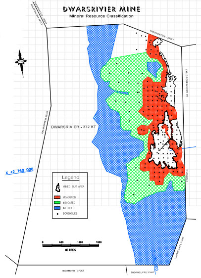
Click the image to view an enlarged version
Mineral Resources have been estimated using Ordinary Kriging, where Cr2O3, FeO, Al2O3, MnO and MgO contents of the LG6 seam and densities were determined, using block sizes of 50 x 50 x 4 metres.
During mining, a slightly diluted run-of-mine ore inclusive of the "false" hangingwall is fed to the beneficiation plant. In the dense media separation part of the plant, the coarse fraction is upgraded to 40% Cr2O3, with a yield of 80%. In the spiral section of the plant the finer fraction is upgraded to 44% Cr2O3, and 46% Cr2O3 respectively, for metallurgical grade fines and chemical grade fines. A 67% yield is achieved in the spiral circuit.
Year-on-year change – 2011
Mineral Resources decreased by 1,83 million tons to 48,77 million
tons mainly due to mining depletion. Mineral Reserves reduced
to 33,44 million tons from 39,50 million tons due to removal of
additional structural blocks, reduction of pillar extraction factor
from 77% to 75% and mining depletions during the year.
| Historical production at Dwarsrivier Chrome Mine | |
| Financial year | Mt |
| 2006/2007 | 1,01 |
| 2007/2008 | 1,24 |
| 2008/2009 | 1,03 |
| 2009/2010 | 0,78 |
| 2010/2011 | 1,25 |
| Dwarsrivier Chrome Mine: Chrome Resources and Reserves | |||||||
| Mineral Resources | Mt | Mn % | Fe % | Mineral Reserves | Mt | Mn % | Fe % |
| Measured | 17,25 | 39,20 | 23,07 | Proved | 9,57 | 35,75 | 22,00 |
| Indicated | 31,52 | 38,97 | 23,01 | Probable | 23,87 | 35,66 | 22,04 |
| Total Measured and Indicated 2011 | 48,77 | 39,05 | 23,03 | Total Reserves 2011 | 33,44 | 35,69 | 22,03 |
| Total Measured and Indicated 2010 | 50,60 | 39,03 | 22,98 | Total Reserves 2010 | 39,50 | 35,75 | 22,00 |
| Inferred | 48,05 | 39,15 | 23,01 | ||||
| Mineral Resources are inclusive of Mineral Reserves. | |||||||
| Totals are rounded off. | |||||||
| Modifying factors: geological losses, mining losses and pillar losses. | |||||||
Competence
The competent person with overall responsibility for the compilation of the Mineral Reserves and Resources Report is Paul van der Merwe, Pr.Sci.Nat, an ARM employee. He consents to the inclusion in this report of the matters based on this information in the form and context in which it appears.
Paul van der Merwe graduated with a BSc (Hons) in Geology from Free State University. He spent four years as an exploration geologist for FOSKOR. He then joined the Uranium Resource Evaluation Group of the then Atomic Energy Corporation of South Africa for 12 years. While employed there he studied geostatistics and spent some time at the University of Montreal, Canada. In 1991 he joined Anglovaal Mining (now ARM) in the Geostatistics Department and evaluated numerous mineral deposit types for this group in Africa. In 2001, he was appointed as Mineral Resources Manager for the ARM group. He is registered with the South African Council for Natural Scientific Professions as a Professional Natural Scientist in the field of practice of geological Science, registration number 400498/83, and as such is considered to be a competent person.
All competent persons at the operations have sufficient relevant experience in the type of deposit and in the activity for which they have taken responsibility. Details of the competent persons are available from the Assmang Company Secretary on written request.
The following competent persons were involved in the calculation of Mineral Resources and Reserves:
| M Burger, PrSciNat | Iron |
| S v Niekerk, PrSciNat | Iron |
| B Ruzive, PrSciNat | Manganese |
| A Pretorius*, PrSciNat | Chrome |
| S Kadzviti, PrSciNat | Iron/Chrome/Manganese |
| *External consultant |
PJ van der Merwe
24 Impala Road, Chislehurston, Sandton
30 September 2011